|
The unfolding energy crisis has coincided with the Grid’s annual assessment of Great Britain’s resilience to disruption to electricity supplies, with the key ‘margin’ figure falling to its lowest in five
years in 2021. Sure enough the predictions came true, with power cuts in
2022 and floods, all adding up to misery for consumers, who had to suffer
without energy for sometimes days.
The frequency of floods seems set to increase relentlessly, where world
leaders have left it a
little late to begin planet cooling action and hope to see some instant
reversal. You can blame climate deniers and the denial lobbyists for that.
COP26 is an example of what you might expect from COP35 in 2030 - sadly,
more blah,
blah, blah. Unless Greta Thunberg makes more of an impact, with our full
support. You cannot expect to raise ocean
levels with melted ice, and not put more water into the cycle of life. The
same as you cannot keep pumping carbon dioxide and other greenhouse
gases into the atmosphere, and expect the planet not to warm up.
About 5 million properties are at risk of flooding in England alone. The impacts can be huge: storms Ciara and Dennis in 2020 cost £360 million in insurance payouts, while the recent Storm Franklin has flooded hundreds of homes across England and Wales. Floods are, by some margin, the most serious natural hazard faced by the UK. A
UK NATIONAL HAZARD THREE TYPES OF FLOODING
- COASTAL
- RIVERS
- SURFACE DRAINAGE
All three forms of flooding could happen in different locations across the UK at the same time. Some flood risks are tied to specific geographic features such as coastline or flood plains, but surface water flooding can occur in a wide variety of locations including towns or cities far from the sea or rivers. Surface water flooding is
particularly difficult to forecast and can happen at very short notice.
ENVIRONMENT AGENCY FLOOD WARNING 16 FEBRUARY 2018
Intense bouts of flooding are set to become more frequent, the Environment Agency has warned today (Friday 16 February).
The warning follows a pattern of severe flooding over the past 10 years linked to an increase in extreme weather events as the country’s climate changes. Met Office records show that since 1910 there have been 17 record breaking rainfall months or seasons – with 9 of them since 2000. As intense storms are becoming more frequent, sea levels are also rising because of climate change.
18 TO 35 MOST AT RISK
Research shows that 18 to 34 year olds are least likely to perceive flood risk to their area, know how to protect their homes or where to go for information. They are also at highest risk of fatality as they are less likely to perceive their personal risk.
In summer 2012, the lengthy period of drought the country had experienced came to an abrupt end when prolonged and intense rainfall increased the risk of flooding from rivers and surface water for long periods. Almost 8,000 homes and businesses were flooded across the country, particularly in the south west.
The winter of 2013 to 2014 started with a coastal surge and record sea levels on the north and east coasts. This was followed by 12 storms in succession and became the wettest winter for 250 years – 11,000 homes were flooded.
UK NATIONAL RISK REGISTER
The winter of 2015/2016 was the second wettest winter on record and a series of storms
(including ‘Desmond’ and ‘Eva’) resulted in heavy and sustained rainfall. 17,600 UK properties were flooded and several bridges collapsed, disrupting access to and from local communities. 61,000 people lost power due to flooding in the Lancaster area. Economic damage was estimated to be about £1.6 billion.
The Flood Risk Management Programme aims to reduce the likelihood and effects of
flooding in England. Similar activity is conducted by all devolved administrations. • Flood Forecasting Centres are partnerships between the Met Office and the Environment
Agency (in England, alongside close collaboration and financial support from Natural
Resources Wales), and the Scottish Environment Protection Agency. These bring together
expertise on flood monitoring, forecasting and warnings. The Department for Infrastructure
in Northern Ireland also works closely with the Met Office in managing flood risks. • Local Resilience Forums in England and Wales, Regional Resilience Partnerships in Scotland and Emergency Preparedness Groups in Northern Ireland
assess risks, develop contingency plans and review them.
Floods: 0345 988 1188 (England, Wales, Scotland) 0300 2000 100 (Northern Ireland)
UK Met weather desk: 0370 900 0100
We
cannot cease the use of fossil fuels overnight, that would be irresponsible,
where civilization needs energy for life. But we can transition with massive
investment in green technology in the hope of eventually reversing the
trend. Or,
all those people in flood risk areas might consider upping stakes and
relocation to higher ground and hope that they can escape the fate of the islanders,
whose homes are sunk. We
must discontinue fossil fuel subsidies, and instead give tax breaks to
investors in renewable energy
companies. Or,
we can build house on stilts, or floating homes. In which case we won't need
service stations for trucks, we'll need moorings to fill up our E-boats, to
be able to travel to work. Impossible of course if factories and offices are
flooded. Unless, they are on stilts or floating structures. Little
hope for Venice and more pressure on Dutch dykes. RIVER SEVERN FLOODING: HOMES AND BUSINESSES EVACUATED
People have been rescued, properties evacuated and trains cancelled due to flooding along the River Severn.
Major incidents have been declared in Bewdley, Worcestershire, and Ironbridge, Shropshire, where severe flood warnings are in place - indicating a risk to life.
Large parts of Shrewsbury town centre are also under water.
There are also dozens of less-severe flood warnings in Herefordshire and Worcestershire.
Nick Green from the Environment Agency (EA) said on Tuesday evening that levels in Bewdley, Worcestershire, were in excess of 16.4 ft (5m) and a further 12in (30cm) was possible which may cause the water to go over the barriers and flood homes.
"There's a lot of water going through the system here," he said.
People living near temporary flood barriers were advised to leave their homes before defences were overtopped, which may happen overnight. The Severn is set to peak in the town on Wednesday.
The flooding follows heavy rain during three storms over the last week - Dudley,
Eunice and Franklin.
Franklin hammered parts of the UK on Monday 21st February 2022, and came days after Storm Eunice killed three people and left 1.4 million homes without power.
There were no train services between Hereford and Shrewsbury on Tuesday because of flooding on the line, with some parts blocked after a landslip. Several roads have also been closed.
River levels were forecasted to remain high for a prolonged period due to further rainfall this week, the EA said.
In Shropshire, a series of evacuations were carried out in different parts of the county.
Homes in the Ironbridge Gorge were among those to be evacuated, including properties in the Jackfield area.
Resident Debbie Stokes said: "I've had to climb through people's front gardens with all my bags.
"We're going to have to look at something... to help us getting out in the future, because it's now, times like this, when you realise just how dangerous this can be."
Rae Evans, from The Wharfage, was evacuated from her home for the fourth time in three years.
The councillor for Telford & Wrekin Council's Woodside ward said: "When I bought the house it said it might flood once in 70 years, so that is quite different.
"I would say I bought the house because the barriers are there, I wouldn't have bought it otherwise."
The Wharfage has been closed to pedestrians. River levels there have reached 6.2m, meaning the area is no longer deemed safe.
The peak was expected on Tuesday afternoon and an EA update at about 19:00 GMT said the temporary barriers at Ironbridge were forecast to potentially exceed their capacity and overtop, causing flooding to properties on The Wharfage.
Earlier, the leader of the council, Shaun Davies, said: "The river still has not peaked and there's still some more stressful hours ahead."
"We are doing all we can to support residents and are preparing for the worst but hoping for the best," Mr Davies said.
"Some properties have no protection from flood defences and are still under water, and we have evacuated properties behind defences that could be breached while supporting those who have decided to stay put."
In Shrewsbury, the River Severn appears to have peaked at 16.9ft (5.15m), 3.9 inches (10cm) short of the record level set in 2000.
One person was rescued by the fire service from Smithfield Road in the town at about 02:45 GMT.
Many roads in the town centre were under water on Tuesday morning. Abbey Foregate car park has been closed, with English Bridge and Welsh Bridge only open to pedestrians.
Residents said they were getting tired of flooding in Shrewsbury, which was becoming more regular.
"While it brings the community together, we are getting fed up of it," Jonnie Ashley, 37, said.
"Every time we flood, it's a big clean-up operation for those by the river, and as our town centre is essentially surrounded by the river, it has an effect on how people can go about day-to-day living."
In Worcestershire, Bewdley is braced for the breaching of flood barriers, where temporary defences at Beales Corner overtopped in 2021.
Clare Dinnis from the EA said "a lot of work" had been done "since last year to put some additional stability behind the barriers and to improve the way we've used them".
She added: "Really importantly, we've got approval for a permanent flood defence here which is in the early stages of design."
Thirty-two flood warnings were issued for the River Severn, including in Worcester where extra flood pumps were installed on Hylton Road, which is flooded and no longer deemed safe to use.
Worcester Bridge was closed to incoming traffic from the St John's side. The Sabrina footbridge was also closed.
Streets including Severn Terrace, Croft Road and Castle Street were also closed due to flooding.
In Ross-on-Wye, Herefordshire, the river has burst its banks and spilled out on to the flood plain. The Wye peaked in Hereford and the Old Bridge has reopened.
The EA has warned that areas around Wilton, Herefordshire, may flood. The water has reached 15.2ft (4.64m) and the highest level ever recorded at Wilton was 15.6ft (4.77m) in February 2020.
LINKS
& REFERENCE https://www.gov.uk/government/news/climate-change-means-more-frequent-flooding-warns-environment-agency https://assets.publishing.service.gov.uk/government/uploads/system/uploads/attachment_data/file/644968/UK_National_Risk_Register_2017.pdf https://www.gov.uk/government/news/climate-change-means-more-frequent-flooding-warns-environment-agency https://assets.publishing.service.gov.uk/government/uploads/system/uploads/attachment_data/file/644968/UK_National_Risk_Register_2017.pdf
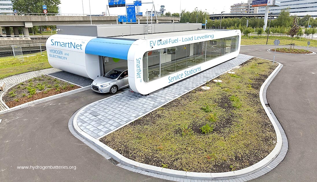
There
is an abundance of clean wind and solar energy that can produce green
hydrogen and
electricity to charge vehicle batteries, and back-up against power cut
blackouts. But there is no transport
infrastructure or other energy storage systems to counter such deficiencies. The SmartNet™
system could be the solution, also providing load levelling for national
grids having to cope with renewables.

Please
use our A-Z
INDEX to navigate this site
This
website is provided on a free basis to
promote zero emission transport from renewable energy in Europe and Internationally. Copyright ©
Universal Smart Batteries and Climate Change Trust 2022. Solar
Studios, BN271RF, United Kingdom. The name SmartNet™ is a trademark.
|